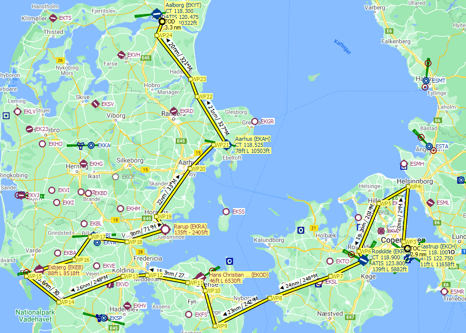
This is a Little Navmap flight plan for the Discover Denmark Bush Trip that is part of Micsoroft Flight Simulator FS2020 World Update V.
I prefer to do these trips in a more relaxed fashion so I can use the drone to scout ahead and explore the points of interest along the route.
Load this flight plan into Little Navmap and turn on the autopilot on the Cessna 172. Set your altitude to around 1000ft and use the autopilot to fly to each waypoint.
I also like to look up the places on Google Maps and view the photos that people have taken. You can use the drone to match up the viewpoint in the photos and see how well the landmarks are represented in FS2020.
Enjoy!


I'm enjoying the bush trips from the world updates. I do have trouble with the dead reckoning though so this has really helped. I also downloaded the Discover Iceland map so thanks for both.
3 years ago
TedFlyer
Dear players, no need to download this flight plan.
Simply go to location:
msfs_root_folder\Official\OneStore\asobo-bushtrip-denmark\Missions\Asobo\Bushtrips\asobo-bushtrip-denmark
and load flight plan into Littlenavmap.
3 years ago
That's handy. I didn't know that. Thanks
3 years ago
ScottOrange
TenPatrol
?How to: Load this "Flight Plan into Little NAV MAP ??,..._ Ive Never done this before), Thanks...
3 years ago
Unzip the download file to your My Documents folder or anywhere you like.
Load Little Navmap then load the .lnmpln file by choosing File -> Open Flight Plan.
3 years ago
ScottOrange
PCAirlines41